Mexico City is sinking: NASA satellite reveals how the city is subsiding by 10 inches per year
Mexico City is experiencing a rapid and alarming rate of subsidence, with satellite imagery revealing that the city is sinking by up to 10 inches (25cm) annually. This phenomenon has been captured in new images from NASA, showcasing the dramatic impact of urban development and groundwater extraction on the ancient lakebed upon which the capital is built.
The metropolis, home to over 22 million people, has been steadily sinking for more than a century. The consequences are visible in many historical structures, including the Metropolitan Cathedral, which has become visibly tilted due to the ground shifting beneath it. This issue is not only an architectural concern but also contributes to a severe water crisis that is expected to worsen over time.
Enrique Cabral, a geophysics researcher at the National Autonomous University of Mexico, highlights the significant damage caused by this subsidence. He explains that critical infrastructure such as the subway, drainage systems, water supply, housing, and streets are all affected. "It's a very big problem," he emphasizes.
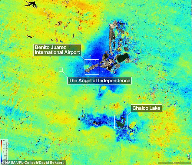
The problem was first documented in 1925, and by the 1990s and early 2000s, certain areas of the city were sinking by approximately 14 inches (35cm) per year. According to recent NASA data, the average rate of subsidence has now increased to 0.78 inches (2cm) per month, resulting in a yearly decline of about 9.5 inches (24cm). Over a century, this has led to a total drop of more than 39 feet (12 metres).
"We have one of the fastest velocities of land subsidence in the world," said Dr. Cabral. The NASA estimates are based on measurements taken between October 2025 and January 2026 using the NISAR satellite, a powerful tool capable of tracking real-time changes on Earth's surface.
Paul Rosen, a NISAR scientist, notes that the project provides valuable insights into what is happening beneath the surface. "It's basically documentation of all of these changes within a city. You can see the full magnitude of the problem," he said.
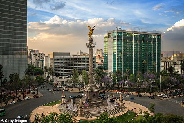
One of the most iconic landmarks affected by this subsidence is the Angel of Independence monument. Built in 1910 to commemorate 100 years of Mexico's independence, the structure stands at 114 feet (36m) tall. However, the land around it has gradually sunk, necessitating the addition of 14 steps to its base.
In Mexico City, the technology represented by NISAR marks a significant advancement in studying and mitigating the effects of subsidence. For many years, the government has largely ignored the issue, focusing only on stabilizing the foundations of monuments like the cathedral. However, recent water crises have prompted officials to invest more in research.
The team hopes to eventually achieve more precise measurements on a building-by-building basis. Beyond Mexico, researchers aim to apply this technology globally to monitor natural disasters, changes in fault lines, and the impacts of climate change, particularly in regions like Antarctica.
Dr. Rosen suggests that NISAR could enhance alert systems, enabling scientists to warn governments about potential evacuations during events such as volcanic eruptions. David Bekaert, a project manager at the Flemish Institute for Technological Research, adds that Mexico City is a well-known hot spot for subsidence, and the images from NISAR represent just the beginning of what is to come.
NISAR continuously monitors the Earth's land and ice surfaces, capturing data every 12 days. Its advanced radar system, featuring a massive drum-shaped reflector measuring 39 feet (12m) wide, is the largest radar antenna ever sent into space by NASA. This technology operates day and night, regardless of weather conditions, to track subtle movements such as land sinking, glacier movement, and agricultural growth.
Craig Ferguson, deputy project manager at NASA Headquarters, explains that NISAR's long wavelength L-band radar will allow for the detection and tracking of land subsidence in challenging environments, such as coastal communities facing both subsidence and rising sea levels.